Lut Desert
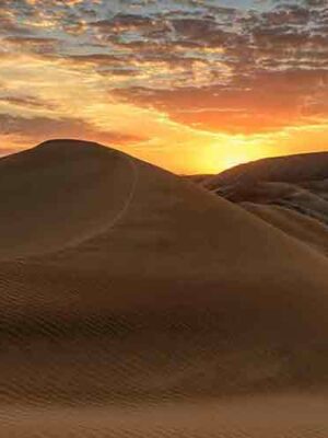
The serene and enrapturing Lut Desert is a vast salt desert spread over 3 provinces of Kerman, South Khorasan, and Sistan and Baluchestan. Iran is located on plateau surrounded by mountains that divide into drainage basins, and the Lut Desert is one of the largest desert basins with an area of over 51,000 square kilometers of fascinating and diverse desert landforms. The Lut Desert is also known as Dasht-e Lut which refers to land without water or vegetation; due to its location in a rain shadow, coupled with high temperatures, the climate is hyper-arid. The region often endures the Earth’s highest land surface temperatures: a temperature of 70.7°C has been recorded within this desert. Over 51 animal species have been discovered here, many of which are endemic to Lut Desert.
Strong NNW-SSE winds blow across the desert between June and October each year, brought on by steep north-south pressure gradient that develops across the region in the spring and summer. These long periods of strong winds thrust sand grains at very high speed, creating transportation of sediment and wind erosion on a massive scale. These processes have created some of the world’s best examples of aeolian yardang/kalut landforms (bedrock features carved and streamlined by sandblasting). The yardangs cover about one third of the desert and appear as enormous and pronounced corrugations across the landscape with ridges and corridors aligned parallel to the dominant prevailing wind. Some yardangs are up to 155 meters high (their ridges can be followed for more than 40 km) and are visible from space.

The stony deserts in Lut are formed by the winds that remove soil from hard rocky protuberances, which leave vast stony desert pavements (hamada) with sand-blasted faceted stones (ventifacts) across about ten percent of the area. A broad black stony desert covers the basaltic Gandom Beryan plateau in the northwest of the core zone. The stony deserts in eastern Lut cover vast pediplains, the extensive plains formed by the coalescence of gently sloping inclined bedrock surfaces that typically slope down from the base of a steeper desert hill.
Massive sand-seas cover almost half the area of the Lut Desert. In the south and east, sands carried by wind and washed in by seasonal streams have accumulated. The active dunes here are considered the largest dunes in the world, with some exceeding heights of 475 meters. The Lut Desert displays a wide variety of dune shapes, including star, linear, compound, crescentic and funnel-shaped ones. The tallest nebkhas (sand dunes that form around vegetation) with 12 meters in height, are found here in the wetter edges of the basin.
Lut Desert
The serene and enrapturing Lut Desert is a vast salt desert spread over 3 provinces of Kerman, South Khorasan, and Sistan and Baluchestan. Iran is located on plateau surrounded by mountains that divide into drainage basins, and the Lut Desert is one of the largest desert basins with an area of over 51,000 square kilometers of fascinating and diverse desert landforms. The Lut Desert is also known as Dasht-e Lut which refers to land without water or vegetation; due to its location in a rain shadow, coupled with high temperatures, the climate is hyper-arid. The region often endures the Earth’s highest land surface temperatures: a temperature of 70.7°C has been recorded within this desert. Over 51 animal species have been discovered here, many of which are endemic to Lut Desert.
Strong NNW-SSE winds blow across the desert between June and October each year, brought on by steep north-south pressure gradient that develops across the region in the spring and summer. These long periods of strong winds thrust sand grains at very high speed, creating transportation of sediment and wind erosion on a massive scale. These processes have created some of the world’s best examples of aeolian yardang/kalut landforms (bedrock features carved and streamlined by sandblasting). The yardangs cover about one third of the desert and appear as enormous and pronounced corrugations across the landscape with ridges and corridors aligned parallel to the dominant prevailing wind. Some yardangs are up to 155 meters high (their ridges can be followed for more than 40 km) and are visible from space.
The stony deserts in Lut are formed by the winds that remove soil from hard rocky protuberances, which leave vast stony desert pavements (hamada) with sand-blasted faceted stones (ventifacts) across about ten percent of the area. A broad black stony desert covers the basaltic Gandom Beryan plateau in the northwest of the core zone. The stony deserts in eastern Lut cover vast pediplains, the extensive plains formed by the coalescence of gently sloping inclined bedrock surfaces that typically slope down from the base of a steeper desert hill.
Massive sand-seas cover almost half the area of the Lut Desert. In the south and east, sands carried by wind and washed in by seasonal streams have accumulated. The active dunes here are considered the largest dunes in the world, with some exceeding heights of 475 meters. The Lut Desert displays a wide variety of dune shapes, including star, linear, compound, crescentic and funnel-shaped ones. The tallest nebkhas (sand dunes that form around vegetation) with 12 meters in height, are found here in the wetter edges of the basin.
Related Tours


7 Day Silk Road Motorized Tour (with COVID-19 Precautions)
06–NIGHT/07-DAY 4X4 SILKROAD TOUR OF IRAN (WITH COVID-19 PRECAUTIONS)
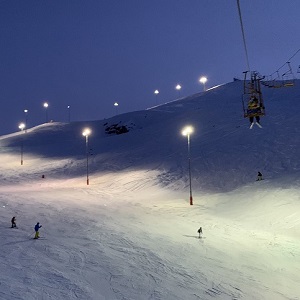
9 Day Ski & Cultural Tour (with COVID-19 Precautions)
8-NIGHT/9-DAY SKI RESORT & CULTURAL TOUR OF IRAN (WITH COVID-19 PRECAUTIONS)